Transportation
As the world has becoming more urban and more mobile, sustainable transportation systems is essential to facilitate citizen mobility to boost productivity while promoting environmental health and well-being. Transportation development has opportunities as well as challenges, namely traffic congestion, lack of access of public transportation services, and so on. Hence, data-driven approach for developing intelligent transportation system is vital, to improve traffic management and to enhance transportation network, for benefiting to an efficient mobility and security.
The research dive for development on transportation hopes to make a contribution to this cause by enhancing the familiarity of researchers with, as well as extracting insights from several datasets, including, toll data, traffic reports, social media, public transportation network data, among others. The research dive aims to generate insights on improvements of transportation system, transportation networks, and public transportation. The event is organized on 19 - 22 November 2017, at Pulse Lab Jakarta office.
The participants were grouped into four research teams, focusing on:
- Task 1 - Modelling highway traffic based on toll data
- Task 2 - Understanding irregular traffic pattern from traffic condition reports
- Task 3 - Estimating traveling time from geolocated social media data
- Task 4 - Analyzing traffic connectivity and efficiency of public transportation
The information package of the fifth Research Dive is accessible here.
Advisors
| Ofyar Z Tamin | Insitut Teknologi Sumatera |
| Nanang Prayudyanto | GIZ/ ITDP |
| Renni Anggraini | Universitas Syiah Kuala |
Participants
Group 1 – Modelling highway traffic based on toll data
| Yosritzal | Andalas University |
| Siti Nurlaela | Institut Teknologi Sepuluh Nopember |
| Muhamad Rizki | Ministry of National Development Planning |
| Herika Muhammad Taki | King Abdulaziz University |
Group 2 – Understanding irregular traffic pattern from traffic condition reports
| Anggun Pratiwi | Institut Teknologi Padang |
| Ilham Nurdayat | Institut Teknologi Bandung |
| Martina Cecilia Adrian | WRI Indonesia |
| Ulfah Aliifah Rahmah | Institut Teknologi Bandung |
| Zakiya Aryana Pramestri | Pulse Lab Jakarta |
Group 3 – Estimating traveling time from geolocated social media data
| Alfa Narendra | Universitas Negri Semarang |
| Lydia Novitriana Nur Hidayat | Universitas Sebelas Maret |
| Okkie Putriani | Universitas Atma Jaya Yogyakarta |
| Ibnu Fauzi | Universitas Atma Jaya Yogyakarta |
| Imaduddin Amin | Pulse Lab Jakarta |
Group 4 – Analyzing traffic connectivity and efficiency of public transportation
| Yori Herwangi | Universitas Gadjah Mada |
| Cahyono Susetyo | Institut Teknologi Sepuluh Nopember |
| Tri Sefrus | Universitas Gadjah Mada |
| Muchammad Zaenal Muttaqin | Islamic University of Riau |
| Muhammad Subair | Pulse Lab Jakarta |
Group 1: Modelling Toll Traffic Pattern - the Jagorawi toll case study
Abstract
Toll road serves the purpose of high mobility and accessibility. However, the conventional payment system had incurred the problem of queuing on toll gates that may reduce toll performances. BPJT or Badan Pengatur Jalan Tol in Indonesia has introduced the policy of new payment system by non-cash payment (GTO) and near-future policy of the MLFF or multilane free-flow system to reduce the queuing problem on payment. Due to different characteristics in toll traffic patterns, there may be differences in the requirement of instalment of this new payment system among different toll roads. These requirements include the optimum number of payment gates needed for each toll and the priority of toll location to be upgraded into GTO and MLFF. To investigate these, we need to understand the impacts of each payment system on the level of queuing, such as the number of cars in queue, the amount of queue time, and the congestion costs due to queue. The queuing theory was used to compare the performance of different payment system (conventional, GTO and MLFF) on Jagorawi toll roads as a case study. A model was developed to understand the pattern of queue and the relationship between queuing, the toll’s gate volume, and the number of booth.
Result
A simulation of the performance of toll gate with difference type of payment system has been conducted. The study found that congestion occurs in the majority of the toll gate, which heavily due to unreliability of the booth services. Rather than increasing the number of booth, simulation of queuing models showed that optimization of toll gate could be achieved with GTO systems. The findings showed that the total number of cars and time in queue at cash payment system is almost 540% higher and annual congestion cost is almost 284% higher than GTO.

Model of the relationship between Traffic Volume versus number of required booth
It can be concluded that the cash payment system should be upgraded to GTO or MLFF for the Cibubur, Cimanggis Utama and Dukuh gates, because the use of cash system at those toll gates were proven to be unsatisfied the Minimum Standard of Services and potentially to cause of billion-rupiah loss due to the congestion at the gate.
Group 3: Estimating Traveling Time Using Social Media Data
Abstract
There is possibility of using geolocated social media data for estimating travel time. The main work is developing method for the data mining thus the data is feasible to use. The geographic information which specifies the location and the time were analyzed and resulting travel time of all OD pairs as well as travel time pattern of sub-district interchange trip within the Greater Jakarta area. Data processing were conducted continued by box plot analysis to remove the outliers data before calculating the travel time. Whereas the travel time pattern visualized travel time taken to do sub-district interchange trip with the help of GIS map. The conclusion is that geolocated social media data are practically able to estimate travel time. However, uncertainty derived from the complex process of tweeting should take into consideration.
Result
From this study, we can conclude that geolocated social media data are practically able to estimate travel time. However, uncertainty derived from the complex process of tweeting should take into consideration.
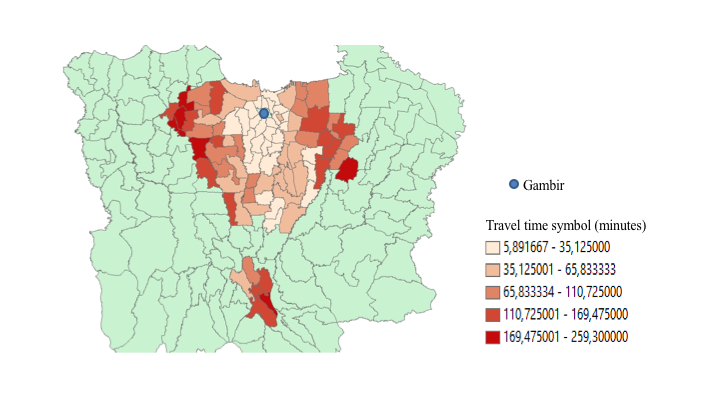
Travel time pattern of Greater Jakarta inter-zone trip to Gambir
Future research would be useful in at least three following directions. First, measurement of biased data due to the time delay. Second, improvement of data mining algorithm to increase the accuracy. The last is possibility in using geolocated data for more detail analysis, such as estimating travel time in road link or inferring link flows based on route estimation.
Group 4: Network Connectivity and Effiency of Public Transportation in Jakarta
Abstract
The effectiveness and efficiency of public transport should be a priority for transportation in developing cities. Despite the efforts from the government to improve public transportation, in Jakarta City, Indonesia, there is still an 9.93% increase of private vehicle annually. The highest contributor to the percentage increase is motorcycles with an average annual increase of 10.54%, followed by an increase in the percentage of passenger cars by 8.75%. In contrast, the number of public transportation increased only by 1.74%. This research evaluates the performance of public transportation in Jakarta by their availability and accessibility. The results indicate that the major problems in public transportations in Jakarta City are the coverage area of the service, route connectivity, and access to public facilities. With average walking distance of 300 m, only 7.78% of Jakarta city area is covered by flexible-stop public transportation services. Furthermore, there are some areas that are not passed by public transport routes, which make about 18.5 million people live in blank spot area. Based on the route connectivity aspect, this research proposes potential location for Transit Oriented Developments (TOD) in Jakarta to improve public transportation services.
Result
This study found that there are many public transport blank spot areas in Jakarta. Based on the coverage area, TransJakarta has been serving 7.78% of Jakarta area (by using 300 meters as an assumption for walking distance), 17.08% of Jakarta area (assumed walking distance 500 meters), and 37.35% of Jakarta area (assumed walking distance 1,000 meters), while the coverage area for flexible stop transport service is 69% (assumed walking distance 300 meters). So that, there is still ineffectiveness of public transport service in Jakarta.

Proposed TOD Locations
There are still many areas with high density population and working age population have not yet covered by existing public transport service. Approximately 3.3 million people in Jakarta live in blank spot areas. Besides, many important public facilities have not covered by public transport service. Thus, there are chances to build TOD concept in Jakarta. In the intersection between Trans Jakarta route and future planning route like MRT and LRT, there are regions that are potential to build as TOD area.
Group 2: Understanding Traffic Pattern from Irregular Traffic Report
Abstract
Traffic pattern has been important subject for transportation study to investigate what and how particular traffic conditions could occurred in an area. Previously, this study limited by lack of data quality that forced researcher to make inference based on limited data. In the advent of technology, high level data quality made available through user-generated content application. In this paper we analyzed time-series and spatial aspect of Jakarta's traffic pattern using Waze incident reports. We employed ARIMA, S-H-ESD, and spatial descriptive analysis to studied traffic pattern categorized in type of incident reports. Our findings showed that, there are possibilities to develop predictive model based on univariate reports pattern, but this model could be developed to incorporated other predictors. Using spatial descriptive analysis, this research conclude that flood event may contribute to regular and irregular traffic condition. However, severity of flood event could not been always reflected from Waze incident reports.
Result
Big data analysis has open up possible attempt to study traffic pattern in unprecedented detail manner. Therefore, researcher and decision maker could gain more comprehension on this subject. In our study, we found that Jakarta traffic pattern can be analyzed in spatial and time-series by using irregular traffic incident report. Time-series model in this research could produce univariate predictive model based on Jakarta traffic condition report.

Spatial pattern of traffic jam report in morning (7 am) and evening (5 pm) peak hour
Although time-series model give insight to Jakarta traffic pattern, ARIMA failed to look into its traffic condition predictor. To understand the predictor, we used anomaly detection and spatial descriptive analysis. Anomaly detection using S-H-ESD able to detected anomaly 1.43% traffic report condition. We cross validate this anomaly with using spatial data and arrived at conclusion that flood may responsible for that condition. Nevertheless,in our dataset, flood condition report do not constantly give valid real world flood condition. In conclusion, despite increasing volume of low granularity data, validation user-generated content report with real world condition is required to ensure fruitful analysis.